The Hayward Fault
One of the Most Hazardous Faults
At 7:53 AM local time, on 21 October 1868, the destructive waves from a Magnitude 7 earthquake on the southern end of the Hayward Fault, quickly traveled across the San Francisco Bay Area and beyond.
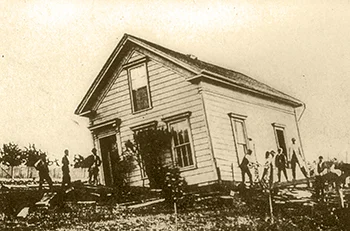
Because of its location in the heart of the Bay Area, then having a total population of about 260,000, and its magnitude, variously estimated as between 6.8 and 7.0, this earthquake was one of the most destructive in California history. Property loss was extensive and 30 people were killed. Five deaths were reported in San Francisco, out of a population of 150,000, where the total property loss was estimated to be $350,000 ($5-100 Million in 2007 dollars). This earthquake was known as the "great San Francisco earthquake" until the Magnitude 7.9 shock on 18 April 1906. The cracking of the ground along the Hayward Fault was traced about 20 miles (32 km) from San Leandro to Warm Springs in Fremont, although modeling of survey data suggest that the fault moved as far north as Berkeley, and from these data the average amount of horizontal movement along the fault is inferred to be about 6 feet (1.9 meters).
USGS » The 1868 Hayward Earthquake
SURE BET: BIG QUAKE IN NEXT 30 YEARS

Friday, March 21, 2008
“The next major earthquake on the Hayward Fault — inevitable anytime now, experts say — will be the Bay Area’s own Hurricane Katrina, affecting more than 5 million people, causing losses to homes and businesses of at least $165 billion and total economic losses of more than $1.5 trillion, scientists warn.
Quake risk worse than we thought
The analysis came from the U.S. Geological Survey in Menlo Park, from Risk Management Solutions, a scientific and engineering firm in Newark, and from the Association of Bay Area Governments. Their view of the past and future was sobering. Records and geologic trenching show that five major quakes struck along the Hayward Fault between 1315 and 1868 — an average of one every 140 years. The 140th anniversary of the last big one falls on Oct. 21.”
David Perlman, Chronicle Science Editor
SFGate | San Francisco Chronicle
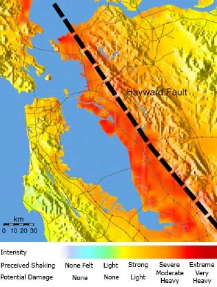
Hayward Fault Shake Map
The “Shake Map” at right shows the shaking intensities expected for a hypothetical scenario earthquake (magnitude 6.7) on the southern Hayward Fault, which last ruptured in 1868 in an event of magnitude about 6.9. Note that damaging shaking would occur over a wide tract and be especially severe around the margins of the Bay in areas underlain by bay mud.
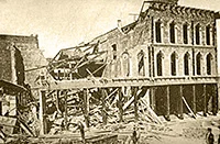
The 1868 shock destroyed a number of buildings in San Francisco. The photo above shows one wrecked building in what is now the Financial District.
Additional Information on The Hayward Fault
USGS » The Hayward Fault
Is It Due for a Repeat of the Powerful 1868 Earthquake?
2008 / PDF / 4 pages / 1.7mb
The Haward Fault: Is it America’s Most Dangerous?
USGS » Active Traces of the Hayward Fault
A Virtual Tour of the Hayward Fault using Google Earth™
Hayward Fault Map and Tour
Source: USGS
Photos courtesy of The Bancroft Library and the Karl V. Steinbrugge Collection, UC Berkeley