Bay Area seismic maps
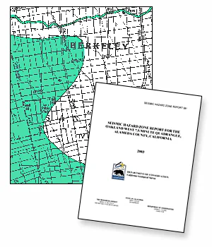
The Seismic Hazards Mapping Act (Act) of 1990 (Public Resources Code, Chapter 7.8, Section 2690-2699.6) directs the Department of Conservation to identify and map areas prone to earthquake hazards of liquefaction, earthquake-induced landslides and amplified ground shaking. The purpose of the Act is to reduce the threat to public safety and to minimize the loss of life and property by identifying and mitigating these seismic hazards. The Act was passed by the legislature following the 1989 Loma Prieta earthquake.
Maps and Reports

Staff geologists in the Seismic Hazard Mapping Program gather existing geological, geophysical and geotechnical data from numerous sources to compile the Seismic Hazard Zone Maps. They integrate and interpret these data regionally in order to evaluate the severity of seismic hazards and designate Zones of Required Investigation for areas prone to liquefaction and earthquake-induced landslides. Cities and counties are then required to use the Seismic Hazard Zone maps in their land use planning and building permit processes. The Act requires site-specific geotechnical investigations be conducted identifying the hazard and formulating mitigation measures prior to permitting most developments designed for human occupancy within the Zones of Required Investigation.
California Geological Survey Seismic Hazards Zonation Program
Interactive Mapping / PDF Maps / PDF Reports
Liquefaction Hazard Map
Alameda, Berkeley, Emeryville, Oakland, and Piedmont, California
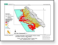
This map shows the liquefaction hazard in the communities of Alameda, Berkeley, Emeryville, Oakland and Piedmont for a magnitude 7.1 earthquake on the Hayward fault. The map predicts the approximate percentage of each designated area that will liquefy and show surface manifestations of liquefaction such as sand boils and ground cracking. Liquefaction is a phenomenon that is caused by earthquake shaking. Wet sand can become liquid-like when strongly shaken. The liquefied sand may flow and the ground may crack and move causing damage to surface structures and underground utilities. The map depicts the hazard at a regional scale and should not be used for site-specific design and consideration. Subsurface conditions can vary abruptly and borings are required to address the hazard at a given location. High quality printable image.
Liquefaction Hazard Map
PDF / 632kb
Ground-shaking Amplification Map
Alameda, Berkeley, Emeryville, Oakland, and Piedmont, California
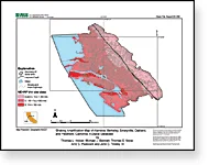
This map shows the capability of the ground to amplify earthquake shaking in the communities of Alameda, Berkeley, Emeryville, Oakland and Piedmont. The National Earthquake Hazards Reduction Program recognizes 5 categories of soil types and assigns amplification factors to each. Type E soils in general have the greatest potential for amplification, and type A soils have the least. These soil types are recognized in many local building codes. Records from many earthquakes show that ground conditions immediately beneath a structure affect how hard the structure shakes. For example, sites underlain by soft clayey soils tend to shake more violently than those underlain by rock. The map depicts the amplification potential at a regional scale, and it should not be used for site specific design. Subsurface conditions can vary abruptly and borings are required to estimate amplification at a given location. High quality printable image.
Ground-shaking Amplification Map
PDF / 412kb
Earthquakes and Faults in the San Francisco Bay Area
1970 to 2003
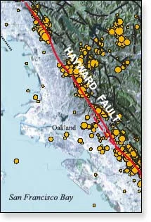
As the USGS map makers indicate, faults located in the greater San Francisco Bay Area are shown. These include the Hayward Fault running through East Bay communities, the San Andreas Fault running from below San Jose through San Mateo and San Francisco Counties and extending into Marin County, the San Gregario Fault cutting across Western San Mateo County, and the Concord and Calavaras Faults in Contra Costa and Eastern Alameda County areas.
The map also shows earthquakes of magnitudes between 1.5 and 7.0 occurring in these areas between 1970 and 2003. Twenty two of these earthquakes measured 5.0 or greater.
Earthquakes and Faults
in the San Francisco Bay Area
JPG Version
33x46 inches / 1.6mb
PDF Version
33x46 inches / 26.8mb
Legend for Map
PDF / 1.4mb